No products
 View larger
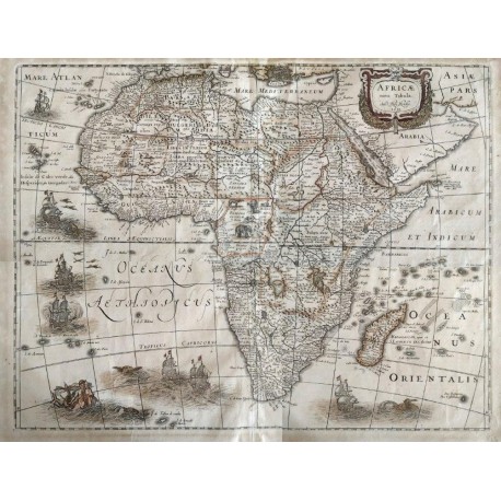
Africae Nova Tabula
Auct Hen HondioUsed
WOODSTOCK: Maps (Maps)
This product is no longer in stock
More info
This is the third state of the attractive 1619 map by Jodocus Hondius II, the highly regarded engraver and cartographer and son of the famous Jodocus I. This state ('edition') of the map was issued between 1631 and 1649 by his brother Henricus Hondius, after is brother's death in 1629. The third state of the map has the imprint date of 1631 and is without the original decorative border. The border of the copperplate was masked so the map could fit into Henricuss Atlas Maioris Appendix. This French edition of the 1631 map (with signature tttt on the recto - text page with headline LAfrique) was published between both 1639-44 and 1646-49. The only change on the map was the date.This map was very popular and was closely copied by other well-known cartographers. The Atlantic Ocean is decorated with six Dutch sailing ships, three sea monsters, six flying fish and Neptune with a mermaid at the bottom left. The Oceanus Orientalis has one Dutch ship and one sea monster. Animals, including an elephant are inserted into the interior for want of towns (Robert Swift). The prime meridian runs through Tenerife and the longitude scale is on the equator. Reference Richard Betz, Mapping of Africa No: 58.3.
Map. Henricus Hondius, Amsterdam. 1645. 49.5 x 37.5cm. The map is age toned, has been de-acidified, but otherwise in very good condition. Book No: 2503570
Reviews
No customer reviews for the moment.


